Members of the European Parliament are being brought up to speed on upcoming votes with background materials prepared by the European Parliamentary Research Service (EPRS). In recent EPRS publications concerning EU fisheries agreements, MarineRegion’s Maritime Boundaries are being used to visualise the area of interest!
User stories
Visualising EU fisheries agreements with Maritime Boundaries for the European Parliament
Fisheries Conservation"Marine Regions data on maritime boundaries provide a great tool for creating tailored maps of coastal countries’ waters, to illustrate precisely what you need, the way you need it."
European Parliamentary Research Service
The European Parliamentary Research Service provides Members of the European Parliament with comprehensive research and analytical support on policy issues concerning the European Union. Furthermore, EPRS offers a wide range of services and products, in order to assist the Members in their parliamentary work, and promotes parliamentary outreach to a broader audience.
Objectives
The European Union has a network of fisheries agreements with coastal states around the world, which provide fishing opportunities for EU vessels in their waters. As part of the agreements, the European Union aims to promote sustainable exploitation of fisheries resources in these countries’ waters.
Parliament’s consent is necessary for the conclusion of EU fisheries agreements. Preceding the vote, EPRS prepares a briefing for the Members of the European Parliament, in order for them to make a fully informed decision. For example, EPRS produced such briefings for Parliament’s votes on the agreements with Cape Verde, Guinea-Bissau and São Tomé and Príncipe, during the June 2020 plenary session.
Methodology
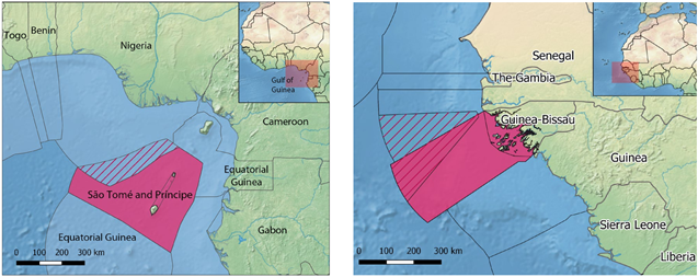
The documents prepared by the EPRS describe the background, the European Commission proposal and Parliament’s position on the subject. Furthermore, a map is included to situate the area of interest. This map displays the maritime boundaries (Exclusive Economic Zones) as provided by Marine Regions. This Marine Regions dataset also includes special management areas, such as the joint development zone between Nigeria and São Tomé and Príncipe or the Guinea-Bissau/Senegal joint management area (cross-hatched).
Used components of the LifeWatch Infrastructure
MarineRegions’ Maritime Boundaries (Exclusive Economic Zones)
The purpose of Marine Regions is to create a standard, relational list of geographic names coupled with information and maps of the geographic location of these features. This improves access and clarity of the different geographic, marine names and allows an improved linking of these locations to databases to integrate biodiversity data, for example.
Marine Regions is also providing the world’s EEZ boundaries. In the past decade the number of users has increased from a few hundred to more than one hundred thousand unique visitors per year. The Marine Region’s Maritime Boundaries and its unique identifier have become a standard for many users from academia, industry, and civil society. Today, the Maritime Boundaries dataset is used in various ways such as a geographic backbone for the World Register of Marine Species, as a geo-unit to calculate fishing activities, or as an assessment unit for the health of our ocean.
Output
Publications
- EU fisheries agreement with Cape Verde
- EU fisheries agreement with Guinea-Bissau
- EU–São Tomé and Príncipe fisheries agreement
- EU fisheries agreement with The Gambia
Contact
info@marineregions.org - eprs@ep.europa.eu
Useful links
Image credits
- Thumbnail: © European Union 2019 – Source : EP / DAINA LE LARDIC
- European Parliamentary Research Service (2019). The Work Of EPRS - The First Five Years: 2014 To 2018. [online] Available at: https://www.europarl.europa.eu/RegData/etudes/STUD/2019/637954/EPRS_STU(2019)637954_EN.pdf [Accessed 24 August 2020].