Satellites can detect mowing events in grasslands
Grasslands encompass vast and diverse ecosystems that provide food, wildlife habitat and carbon storage. Mowing dates and frequencies are major aspects of grassland use intensity, which have an impact on their ecological value as habitats.

The LifeWatch Wallonia-Brussels, a team highly experienced in land cover and land use mapping through remote sensing methods and GIS analysis, set up a study to quantitatively and statistically assess the potential of Sentinel-1 C-band SAR (Synthetic Aperture Radar imagery) for detecting mowing events in various agricultural grasslands.
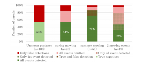
Results show that 54% of mowing events could be detected in hay meadows, based on coherence jumps. Those sudden changes or jumps in between two satellite runs are indicators for the change in vegetation structure. Grazing events were identified as a major confounding factor, as most false detections were made in pastures. Parcels with one mowing event in the summer were identified with the highest accuracy (71%). Overall, this study demonstrates that mowing events can be detected through Sentinel-1 coherence.
Read the whole article here .


